Indexed palette
A synthetic 8-bit elevation raster of a mountainous coast, stored as one byte per pixel as many older terrain formats store it, and drawn through the 256-entry palette that travels with it. Codes 0 to 63 are water, 64 to 191 are land from sea level to the snow line at 2000 m, and 192 to 255 are ice, so each code is a step of about 16 m. The colourbar of an indexed scale draws one block per entry, so its 256 blocks are the palette itself, and its ticks sit at the centres of the entries they name: here three entries in the middle of the three ranges are labelled by name rather than by number.
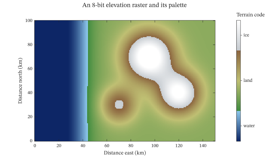
The figure above is live, drawn in the browser by the same engine that draws the viewer: drag it to pan, and click it to zoom with the wheel. Download the PDF for the vector figure that IronLAB exports, or read how to embed a figure of your own.
Source
The figure is built by the following code.
use ironlab::prelude::*;

pub const TITLE: &str = "Indexed palette";
pub const DESCRIPTION: &str = "A synthetic 8-bit elevation raster of a mountainous coast, stored as one byte per \
     pixel as many older terrain formats store it, and drawn through the 256-entry palette that travels with it. \
     Codes 0 to 63 are water, 64 to 191 are land from sea level to the snow line at 2000 m, and 192 to 255 are ice, \
     so each code is a step of about 16 m. The colourbar of an indexed scale draws one block per entry, so its 256 \
     blocks are the palette itself, and its ticks sit at the centres of the entries they name: here three entries in \
     the middle of the three ranges are labelled by name rather than by number.";

/// The number of samples east to west.
const COLUMNS: usize = 240;

/// The number of samples south to north.
const ROWS: usize = 160;

/// The palette code of sea level.
const SEA_LEVEL_CODE: f64 = 64.0;

/// The height of one palette code, in metres: the 128 land codes span sea level to the snow line at 2000 m.
const METRES_PER_CODE: f64 = 2000.0 / 128.0;

/// Returns the elevation, in metres, at a point `x` kilometres east and `y` kilometres north of the origin: a coast
/// that runs north to south with a ridge of three summits inland of it.
fn elevation(x: f64, y: f64) -> f64 {
    let coast = 900.0 * ((x - 40.0) / 12.0).tanh() - 300.0;
    let summits = [(95.0, 70.0, 2900.0, 14.0), (120.0, 40.0, 2500.0, 12.0), (70.0, 30.0, 1500.0, 10.0)];
    let peaks: f64 = summits
        .iter()
        .map(|&(cx, cy, h, w)| h * (-((x - cx).powi(2) + (y - cy).powi(2)) / (2.0 * w * w)).exp())
        .sum();
    coast + peaks
}

/// Returns the palette code of an elevation, clamped to the 256 codes.
fn code(elevation: f64) -> u8 {
    (SEA_LEVEL_CODE + (elevation / METRES_PER_CODE).floor()).clamp(0.0, 255.0) as u8
}

/// Returns `count` colours interpolated linearly between the given colours, which are evenly spaced along the ramp,
/// from the first colour to the last.
fn ramp(colors: &[Color], count: usize) -> Vec<Color> {
    let last = colors.len() - 1;
    (0..count)
        .map(|k| {
            let position = k as f32 / (count - 1) as f32 * last as f32;
            let i = (position.floor() as usize).min(last - 1);
            let (a, b, f) = (colors[i], colors[i + 1], position - i as f32);
            Color::rgb(a.r + (b.r - a.r) * f, a.g + (b.g - a.g) * f, a.b + (b.b - a.b) * f)
        })
        .collect()
}

pub fn figure() -> Figure {
    let x = linspace(0.0, 150.0, COLUMNS);
    let y = linspace(0.0, 100.0, ROWS);
    let codes = ByteMatrix::from_fn(ROWS, COLUMNS, |row, col| code(elevation(x[col], y[row])));

    // The palette: 64 blues for water, 128 greens and browns for land and 64 greys for ice.
    let mut palette = ramp(&[Color::rgb(0.05, 0.15, 0.40), Color::rgb(0.55, 0.78, 0.92)], 64);
    palette.extend(ramp(
        &[
            Color::rgb(0.25, 0.55, 0.25),
            Color::rgb(0.75, 0.75, 0.45),
            Color::rgb(0.55, 0.40, 0.25),
        ],
        128,
    ));
    palette.extend(ramp(&[Color::rgb(0.78, 0.80, 0.82), Color::WHITE], 64));

    let mut fig = Figure::new()
        .size_mm(160.0, 95.0)
        .tiles(1, 2)
        .fit_col(1)
        .title("An 8-bit elevation raster and its palette")
        .tag("image")
        .tag("color-scale")
        .tag("colorbar")
        .tag("aspect")
        .tag("map")
        .parameter("dimensionality", "2D")
        .parameter("artists", 1)
        .parameter("data_points", 38_400)
        .parameter("has_legend", false);
    let terrain = fig
        .indexed_scale(palette)
        .tick_labels([(32, "water"), (128, "land"), (224, "ice")])
        .title("Terrain code")
        .id();

    let mut ax = fig.axes(0, 0);
    ax.scalar_image(&codes)
        .pixel_columns(x[0], x[COLUMNS - 1])
        .pixel_rows(y[0], y[ROWS - 1])
        .color_scale(terrain);
    ax.xlabel("Distance east (km)")
        .ylabel("Distance north (km)")
        .aspect(Aspect::Equal);
    fig.panel(0, 1)
        .colorbar(terrain)
        .title_placement(ColorbarTitlePlacement::Above);
    fig
}